
Last Wednesday, my Seattle group started up a new D&D campaign set in a friend’s homebrew world. She unveiled the map for her setting, and it was amazing — pro-level cartography, tantalizing and inviting and clear, both functional and beautiful. She mentioned in passing that she’d created it in Wonderdraft, a mapping tool I’d never heard of before, so after the game I asked her how hard it was to create a map that awesome using Wonderdraft.
Not that hard, she said.
Now, to me that sounded like Michael Jordan casually sinking shots from mid-court, one after another, without even looking, while saying “It’s not that hard.” But she gave me some benchmarks for why it wasn’t that hard, how it involved a lot of painting (a plus for me), and how much simpler it was than learning Photoshop. That last one was key, because I’ve dabbled with Campaign Cartographer and it 1) felt a lot like trying to learn Photoshop, which I found to have a cliff-shaped learning “curve,” and 2) made me want to give up my worldly possessions and go live in the woods as a hermit.
So I took the plunge, watched a couple YouTube tutorials (D&D Breakfast Club’s tutorial 1 of 4 and Icarus Games’ video on transferring maps to Wonderdraft), and within 15 minutes I’d determined that 90% of what I wanted in a professional Unlucky Isles map was something I could do in Wonderdraft — and, like my friend said, it wouldn’t be that hard.
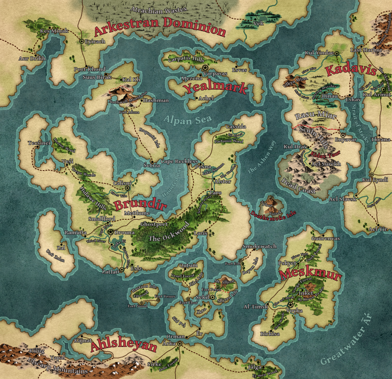
TL;DR: The new map of the Unlucky Isles
This map took me about 20 hours to make (including time spent finding assets and learning how to use Wonderdraft):
And here’s its predecessor:

Some realizations
I was worried I’d have to create every map twice so that I could take advantage of Worldographer’s numbered hexes, a feature not found in Wonderdraft. But Wonderdraft has a robust user community, and that community has created a tool to give you numbered hexes. I also realized that while I always build my maps with old-school hexcrawling in mind, 99% of my fantasy RPG play has not been old-school hexcrawls.
In fact, 99% of that play has been in games that would benefit more from a Wonderdraft-style map than an old-school hex map. I’ve also found that I’m not taking advantage of one of Worldographer’s killer apps, which is the ability to map the same setting at the world, continent, and more local levels (with automagical terrain generation and child maps). And when I can drop a hex grid on my Wonderdraft map, run an addon to number those hexes, and have the best of both worlds (no pun intended), that really seals the deal.
Whoa, that’s too many cities! And too many people
Redoing this map — and expanding it — in Wonderdraft prompted me to name a lot more stuff. While browsing r/Wonderdraft I came across a comment on a user’s lovely map about there being too many settlements (not a universal truth, but a salient point for an RPG setting), and that plus my own mapmaking made me realize that I had too many cities in the Isles. I’ve wondered whether the Isles were too populous ever since I started ballparking the numbers, but this threw it into sharp relief.
So, a reckoning. I wiped out all the labels I’d created on my first big “map day” (after jotting down all the names for future use), rolled up my sleeves, and tucked into some revisions.
I’m leaning on two sources here, and moving WWN itself to the background (because those numbers skewed high): Medieval Demographics Made Easy (MDME), which the ever-brilliant S. John Ross has graciously made freely available with a very permissive license (and, as such, is now hosted here on Yore); and a Medium post by Lyman Stone looking at the same topic through the lens of Game of Thrones. They’re in broad agreement, which is good enough for me.
Let’s start with approximate hex counts, not worrying yet about what might count as wilderness (except in the lone very obvious case):
- Arkestran Dominion: 215 hexes not counting the Wastes
- Yealmark: 41 hexes
- Brundir: 420 hexes
- Rasu Miar: 165 hexes
- Mainland Kadavis: 133 hexes of Kadavis proper on this map
- Meskmur: 115 hexes
- Ahlsheyan: 225 hexes on this map
I’m mapping in 6-mile hexes, which contain roughly 9 square miles. Ross and Lyman agree that a medieval (~1,000-1,500, more or less) population density of 100 people per square mile was an outlier reserved for only the most populous, arable nations. At 900/hex that’s 1,100 people/hex fewer than WWN posits — and most countries in the Isles will be well below 100/square mile.
Two examples:
- Ross notes that 14th century England had about 40 people/sq. mi.
- Lyman notes that if you average the figure from 1,000 to 1,500 CE, Scotland had about 4-8 people/sq. mi. (and, disagreeing with MDME, England comes out to 11-30 people/sq. mi.)
Whichever stat you use, the country I tend to treat as my benchmark for medieval population figures — England — has a lot fewer people/sq. mi. than my original estimates for the Isles. There’s also the whole fuzzy consideration that while the average medieval European country was just rotten with hamlets and thorps and whatnot, so dense with settlements that you couldn’t throw a stone without hitting the next one over, worlds designed for D&D-style adventuring need blank spaces.
Just to get the ball rolling, let’s say Brundir has 40 people/sq. mi. (420 hexes, not counting any as wilderness). That’s 151,200 people. WWN and MDME would both put about 5,000 people in Brundir’s largest city; WWN postulates about 15,000 in cities nationwide. The next largest would be 2,500. Both of those are pretty small cities — in fact, MDME doesn’t even consider a settlement a city if it has fewer than 8,000 people in it.
So how about Brundir with a population density of 75 people/sq. mi.? That gives Brundir the following stats:
- Population 283,500
- 28,000 in cities
- 9,300 in the largest city
- 3,780 sq. mi. of territory (420 hexes)
- 1,575 sq. mi. of which is farmland (175 hexes, using MDME’s formula of 1 square mile of farmland supporting 180 people)
That feels more right to me than my initial WWN-driven population estimates. I don’t need to delve any deeper for the time being, but when I do this is the route I’ll be following.
Wonderdraft settings
Two things that have really been making Wonderdraft sing for me are Mythkeeper, a free tool which automates adding new assets (symbols, etc.) to Wonderdraft, and the Cartography Assets site, which is chock full of free and paid Wonderdraft asset packs. I fell in love with symbols pulled from old maps, so all of the forests, mountains, etc. on my Unlucky Isles map are drawn from historical examples.
For the sake of my sanity — and so that, if you like, you can create maps in this style — I’m recording some of the Wonderdraft choices and options I’ve used to create this map. Some things, like the map textures, are visible on a finished map when you load it in Wonderdraft — but many are not. Which of the seven sets of mountain assets did I use? What brush opacity did I color them with? That’s what this list is for.
In general, I’m always using brush #3 (the blotchy spray), and varying scales but usually 50% or below. All the names (Vischer, etc.) refer to assets or asset packs on Cartography Assets.
- Mountains: Vischer or Widman mountains, #976035, brush opacity 1.0
- Snowcapped peaks: Just paint the tips #FFFFFF, brush opacity 0.5
- Volcanoes: Van Der Aa mountains, AoA Volcanoes Pencil smoke, #976035, brush opacity 1.0
- Snowbound mountains (as in the Ice Courts): Paint the tips #FFFFFF, brush opacity 1.0, then add light squirts of #976035, brush opacity 0.25, just to break things up visually
- Barren hills: Ogilby hills, #C8AD93, brush opacity 0.5
- Verdant hills: Vischer regular hills (which are grassy/overgrown), so far only painted as forests
- Forests: Vischer or Van Der Aa assets, with individual Vischer trees mixed in, #74A035, brush opacity 0.5; usually I add a few squirts of #2E6020, brush opacity 0.5, for variety
- Deep Forests: #2E6020, brush opacity 0.5
- Dead trees: Mix of default dead trees and Zalkenai’s dead trees, black, varying scales, #828864, brush opacity 0.5
- Marshes: Vischer wetlands assets, with a few Widmer individual trees mixed in for variety, #37835E
- Aausti marshes: As above, but instead of individual trees mix in Ogilby scrubs
- Scrubland: Mix of Ogilby and Vischer scrub, #BAB26D, brush opacity 0.5
- Farmland: Vischer furrowed fields, #BAB26D with a couple blasts of #74A035 for good measure
- Broken lands: Popple hills, so far only used in the Atrachian Wastes so they were painted as dead trees
- Devastation of The God That Eats: As broken lands, but without the hills and with Ogilby heaths
- Vineyards: Vischer vineyards, a few squirts of #735B79, brush opacity 0.25
- Snow-covered terrain: #FFFFFF, brush opacity 0.1, applied in single-click “squirts” with the widest brush possible for the terrain, aiming for a light, blotchy whiteness
- Ruins/mysterious towers: Vischer ruins and monuments mixed with Van Der Aa towers, with Popple scrubs thrown in until it looks right; #828864, brush opacity 0.25, with a few squirts of brush #1 around it for blending
- Weird obelisks: Vischer ruins and monuments; colored #828864, brush opacity 0.5 (So far, only used for the Thefaine in Aaust.)
- Settlements: Custom Colors assets (included by default), #00000
- Cities: Circle with dot in the center, 50% scale
- Capital cities: Circle with star in the center, 50% scale
- Towns: Dot, 35% scale
- Forts: Filled diamond, 35% scale
- Castles: Box with X in it, 35% scale
- Roads: Solid line, #411602, width 3, roughness 0.33
- Crappy roads: Dashed line, #411602, width 3, roughness 0.33
- Rivers: Width 4, roughness 2, meander distance 0.6, generally with “river source fade-in” turned off
- Borders: Dotted line, #BB101C, width 4, roughness 0.33
- Raise/Lower Landmass Tool for coastlines: Roughness 2
- Labels: Gentium Book Basic Bold (included), outline #000000 thickness 1 (except for bodies of water)
- Nations: #B93841, font size 48, curvature 0.15, always horizontal
- Cities, capital cities, towns: #B9B4B4, font size 20, no curvature, always horizontal
- Castles, forts: As cities, but font size 14
- Ruins: As castles, but curvature -0.2 instead of horizontal
- Large bodies of water: #7EABA1, font size 36, outline 770C232C, curvature varies but always curved, orientation varies
- Small bodies of water: As large, but font size 14 or 24
- Rivers: #B9B4B4, font size 10, curvature varies but always curved, orientation varies
- Major geographic features: #B9B4B4, font size 24, curvature varies but always curved, orientation varies
- Minor geographic features: #B9B4B4, font size 14, curvature varies but always curved, orientation varies
I also like to mix in squirts of brush #1 (spray paint), 0.5 opacity, to blend the transitions between painted areas (primarily the default “not arable” beige and “arable” greenish-brown).
Non-English letters in labels
I’ve found that it can be handy (on PC) to have the Character Map app open for easy cutting and pasting into Wonderdraft labels. Every character won’t paste, presumably because my Wonderdraft font choice doesn’t include it — but enough do for me to get the job done.
And on the language front, Lexicity is another awesome resource for dead languages. It’s not as straightforward as Palaeolexicon, since it curates links rather than simply presenting dictionaries — but it has a lot of resources to offer.
Summing up
Wonderdraft isn’t as simple as Worldographer. For the purposes of creating a setting using Worlds Without Number (paid link), it is 100% Too Much Gun. When I’m working on a setting, creating a polished, beautiful map is a step that becomes a vast gulf between me and producing actual gameable content, and it leads to abandoned projects. It’s the antithesis of WWN’s highly successful “never give up your momentum, never stall out trying for perfection” philosophy.
But at this stage, with a full cycle of WWN’s region creation and kingdom creation under my belt (as in, I could run a game set in the Isles tonight), and as I’ve already moved on to a second region of Godsbarrow, making a pretty map of the Isles isn’t a roadblock of any kind. I don’t need it, and it’s not holding anything up; my Worldographer map is perfectly functional for play.
There is, however, no substitute for sitting down to play and having a gorgeous map in front of you — one that raises questions, makes you want to explore, and makes the setting feel real. If you’ve ever opened up an AD&D Forgotten Realms product and unfolded one of those glorious maps, you know that feeling. I want that for Godsbarrow, and I hope my map succeeds at that goal.
(This post is one of a series about worldbuilding with Worlds Without Number.)
I really like the new maps; they have an improved Mystara/Basic edition feel and read cleanly.
It has a very different feel — the first map was a perfectly good Isle of Dread GM’s secret key (where clarity helps so much), but the new map IS much more inviting. Some things really pop and get me interested — like the Northwall mountains.
Thank you so much, Scott! That is some high praise right there.